Thinking about buying or renovating on North Bay Road and wondering where the waterline leaves you? On Miami Beach’s bayfront, setbacks and seawall rules shape what you can build, where you can place it, and how fast you can get it approved. If you want a dock, pool, lift, or a major addition, the details matter. This guide breaks down the agencies, setback basics, seawall expectations, and a clear checklist so you can move forward with confidence. Let’s dive in.
The rules that govern North Bay Road waterfronts
Waterfront work on North Bay Road often involves multiple layers of review. Federal oversight can apply when work occurs in navigable waters or seaward of mean high water. State review considers coastal construction and impacts to submerged lands. County and city rules set zoning setbacks, building standards, and floodplain requirements.
You will likely interact with the City of Miami Beach for zoning and building permits, Miami-Dade County for building and environmental review, and state or federal agencies if your project touches Biscayne Bay. Common stakeholders include the U.S. Army Corps of Engineers, the Florida Department of Environmental Protection, the South Florida Water Management District, and resource agencies that protect marine habitat. Key references include the Florida Building Code, FEMA flood maps and local floodplain ordinances, and the City of Miami Beach Code of Ordinances.
What waterfront setbacks mean for your property
A waterfront setback is the horizontal distance required between the seawall or legal shoreline and your structure. Setbacks limit how close you can place principal buildings, accessory structures, and water-dependent improvements along the bay. On North Bay Road, the measurement point may be the mean high water line, the existing bulkhead, or the recorded shoreline on your survey.
Principal buildings and major additions typically observe larger setbacks. Pools, decks, and other accessory features may follow different, often smaller, standards. Docks and boathouses involve both lateral placement along the shoreline and limits on extension into the water to protect navigation and habitat.
How setbacks are measured on Biscayne Bay lots
Your survey controls the conversation. Setbacks can be measured from the mean high water line, an established seawall, or the recorded shoreline shown on plats. The vertical dimension is separate, with FEMA Base Flood Elevation guiding finished-floor and deck heights.
When a parcel has unusual conditions, recorded easements or unique shoreline geometry can affect how the setback applies. Early coordination with the City of Miami Beach and Miami-Dade County helps confirm which reference line governs your lot.
Variances, exceptions and riparian rights
If strict compliance creates practical difficulty, a variance process may be available. Variances typically require technical justification, public notice, and sometimes mitigation. Florida riparian rights allow reasonable access to the water, but those rights do not replace permits.
Ownership to the waterline can vary, especially on filled or historically modified shorelines. Always confirm the recorded plat, deed, and current survey before designing improvements.
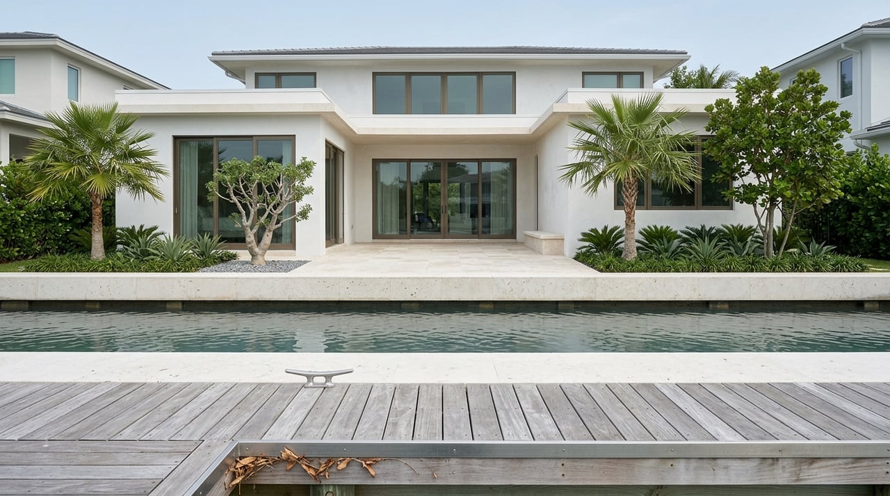
Seawalls, heights and current policy trends
Seawall design is increasingly tied to flood resilience. Designers consider FEMA Base Flood Elevation, local freeboard, and evolving municipal standards that anticipate sea-level rise and more frequent tidal flooding. Many South Florida communities have raised expectations for shoreline protection, which can influence top-of-wall elevation and durability.
Engineering is critical. Typical submittals include stamped plans, a current survey, geotechnical data, and construction sequencing with erosion and dewatering controls. Reviews may account for future conditions and request adaptation features, such as higher cap elevations or improved drainage allowances.
As the property owner, you are usually responsible for seawall maintenance and replacement. Deferral can affect insurance, liability, and future permitting. A professional assessment before purchase or design can reveal hidden issues like tieback deterioration or toe scour.
Docks, pools and additions: what to expect
Docks and boat lifts often require joint permits if any portion is over submerged lands or navigable waters. Environmental review looks for seagrass, mangroves, and sensitive habitat. Designs may need to limit shading or use open-grate decking to allow light penetration. Placement is also reviewed to preserve navigation and neighbor access.
Pools near the shoreline face structural and drainage concerns. Local rules commonly require separation from the seawall to prevent undermining and to allow maintenance access. Dewatering during construction near the bay can trigger additional environmental review.
Additions must navigate setbacks, lot coverage, and flood elevation requirements. If an improvement is substantial under floodplain rules, it can trigger broader code compliance. Any increase in hardscape or building footprint usually requires updated drainage plans.
Timelines, costs and closing risks
Plan for a multi-step permitting path. Local zoning and building review can take weeks to a few months, depending on complexity and document quality. Joint state and federal permits for docks often add multiple months and may include public notice and environmental review. Complex waterfront projects commonly span 3 to 9 months in combined review.
Costs vary widely with length of shoreline, access, soil conditions, and material type. Get multiple bids and include engineering, permit, mitigation, and neighbor coordination costs in your budget. During resale, unpermitted or noncompliant work can delay closing and require remediation, so verifying permit history up front is essential.
Buyer and owner checklist for North Bay Road
- Obtain a current ALTA survey that shows the seawall, waterline, easements, and all improvements.
- Request permit histories from the City of Miami Beach and Miami-Dade County for seawalls, docks, pools, and major additions.
- Order a professional seawall condition assessment from a marine or structural engineer.
- Confirm your flood zone and Base Flood Elevation through FEMA maps or local floodplain staff, and collect any elevation certificates.
- Check recorded easements, rights-of-way, HOA rules, and coastal development agreements.
- Consult City of Miami Beach Building and Planning staff and Miami-Dade reviewers early to confirm setbacks, freeboard, and permit needs for your parcel.
- Engage a licensed marine or structural engineer and experienced coastal contractor before design.
Pro tips to keep your project moving
- Start design with a clean survey, geotechnical data, and preliminary agency feedback.
- Anticipate future conditions by discussing design elevations and adaptation features with your engineer.
- Sequence dewatering, erosion control, and habitat protection in the construction plan to reduce review friction.
- Coordinate with neighbors if dock alignment or shared access may be affected.
- Keep organized records of permits, inspections, and as-builts to support future resale and insurance.
Work with a team that understands the waterfront
On North Bay Road, details at the waterline drive value. The right plan protects your lifestyle and your investment while keeping you on track for approvals. If you want senior-level guidance on due diligence, feasibility, and negotiation for a bayfront purchase or sale, our team is here to help.
Ready to discuss your goals on North Bay Road? Schedule a Private Consultation with The Johnston Carmenate Duchon Group at The Corcoran Group.
FAQs
What are waterfront setbacks on North Bay Road?
- Setbacks are required distances from the seawall or legal shoreline to structures, with principal buildings, accessory features, and docks each subject to different rules set by the City of Miami Beach and related agencies.
Who approves docks and boat lifts on Biscayne Bay?
- Docks and lifts often require permits from the City of Miami Beach and Miami-Dade County, plus joint state and federal approvals when work occurs over submerged lands or navigable waters.
How long do waterfront permits typically take?
- Local reviews may take weeks to a few months, while state and federal permits can add multiple months; complex projects commonly plan for 3 to 9 months total.
How do seawall heights get set in Miami Beach?
- Designers consider FEMA Base Flood Elevation, local freeboard, and evolving municipal standards that account for sea-level rise and nuisance flooding, with engineering to manage stability and drainage.
Can I install a pool close to the seawall on North Bay Road?
- Pools usually need a setback from the seawall, along with drainage and dewatering controls; structural, plumbing, and electrical permits are required and may trigger environmental review.
Do floodplain rules affect additions to waterfront homes?
- Yes, additions must meet flood elevation standards and may trigger substantial improvement thresholds, along with stormwater and lot coverage compliance.
What risks come with unpermitted seawalls or docks at closing?
- Unpermitted or noncompliant work can delay closing and require remediation, and it may impact insurance and financing; verify permit history early in due diligence.